Utility Locating Guide: What To Do About An Exposed Power Line

utility locating services

Key Takeaways

  • Contact your utility company immediately if you find an exposed power line.
  • Use professional utility locating services to prevent accidental utility strikes.
  • Ground penetrating radar and metal detectors are essential tools for locating underground utilities.
  • Always mark utilities with white paint before any excavation.
  • Distinguish between public and private utilities to ensure proper maintenance and safety.

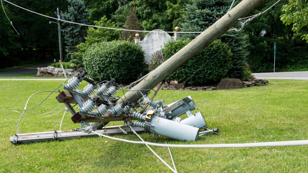
An exposed power line is a serious hazard that needs immediate attention. If you find an exposed power line on your property, it’s essential to stay away from it and contact your local utility company immediately. Proper utility locating services can help identify the exact location of other underground utilities to prevent further issues.

Discovering an exposed power line can be alarming, but knowing how to handle the situation is crucial for your safety and the safety of others. In this guide, we’ll cover the steps to take when encountering an exposed power line and the importance of using utility locating services to prevent such occurrences in the future.

Signs of a Utility Strike

A utility strike occurs when an underground utility line is accidentally hit during excavation or construction. Recognizing the signs of a utility strike is crucial for ensuring immediate and appropriate action. Here are some common indicators that a utility strike has occurred:

1. Hissing Sound

A hissing or whistling noise is a clear sign that a gas line has been punctured. This sound results from gas escaping under pressure and can signal a dangerous situation that requires immediate evacuation and emergency response.

2. Sudden Loss of Service

If you experience an unexpected loss of water, electricity, or internet service, it may indicate that a utility line has been damaged. For example, hitting an electrical line can result in power outages, while damaging a water line can cause a sudden drop in water pressure or complete loss of water supply.

3. Unusual Smells

A strong smell of gas or chemicals is a serious warning sign of a utility strike. Natural gas is often odorized with a sulfur-like scent to make leaks detectable. If you notice this smell, evacuate the area immediately and contact emergency services.

4. Visible Damage

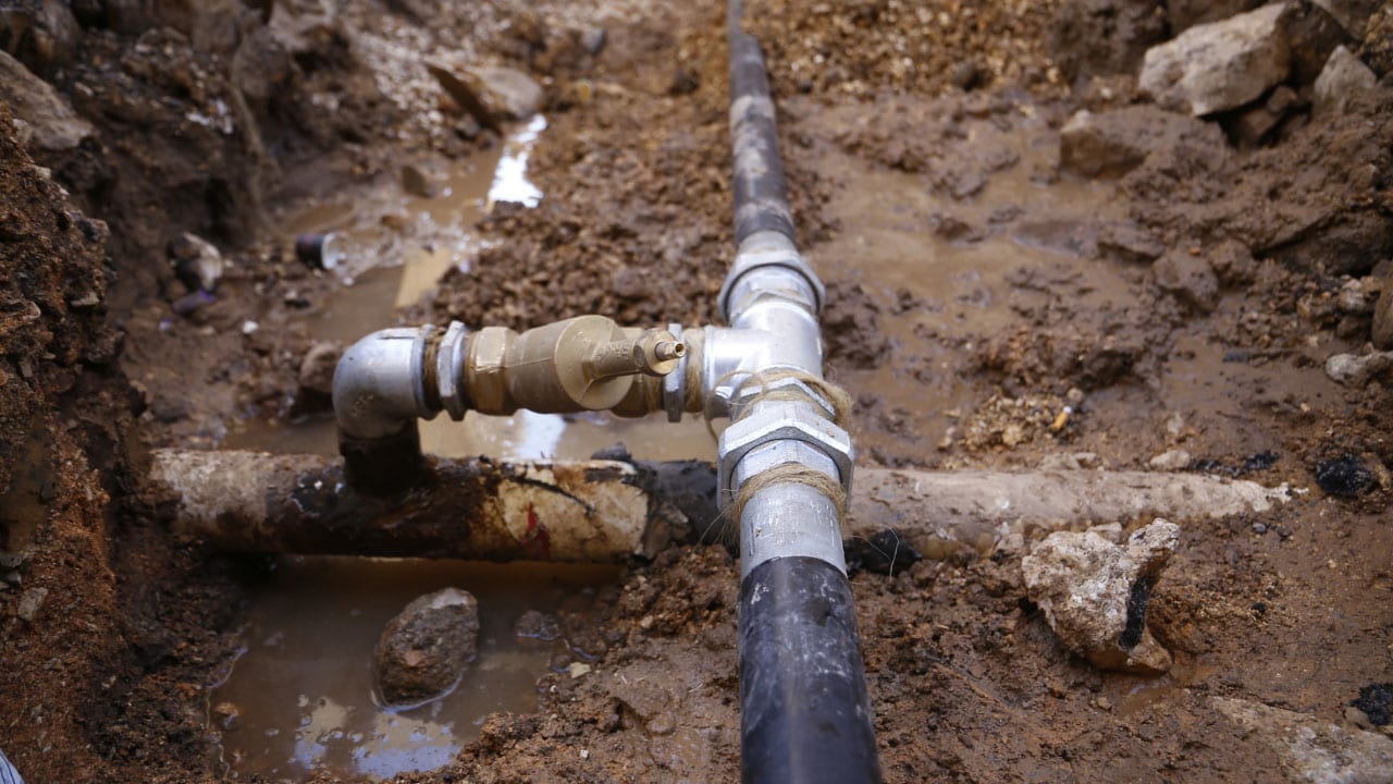
Seeing exposed or damaged utility lines, such as cut wires or broken pipes, indicates a utility strike. It’s important to cease all work and secure the area to prevent further damage or injury.

5. Water or Soil Eruption

If water or mud starts erupting from the ground, it likely means a water or sewer line has been compromised. This can lead to flooding and contamination, necessitating prompt action to mitigate damage.

Immediate Steps to Take When You Find an Exposed Power Line

1. Stay Clear and Alert Others

The first and most important step is to stay at least 30 feet away from the exposed power line. Ensure that others are aware of the danger and keep them away as well. Do not attempt to touch or move the power line under any circumstances.

2. Contact Your Utility Company

Immediately contact your utility mapping company to report the exposed power line. They have the necessary resources and expertise to handle such emergencies. Providing them with the exact location of the exposed line will help them respond more efficiently.

3. Avoid Contact with Metallic Objects

Ensure that no one comes into contact with any metal objects near the exposed power line, as metal can conduct electricity. Keep pets and children inside until the area is deemed safe by professionals.

Understanding Utility Ownership

It’s important to distinguish between public and private utilities. Public utilities are typically maintained by the utility company, while private utilities are the responsibility of the property owners. Private utility locators can be hired to identify and mark private utility lines on private property.

Utility owners maintain records of their infrastructure, which can be useful in locating underground lines. Accessing utility owner records can provide additional information about the location and type of utility lines on your property.

Legal and Safety Considerations

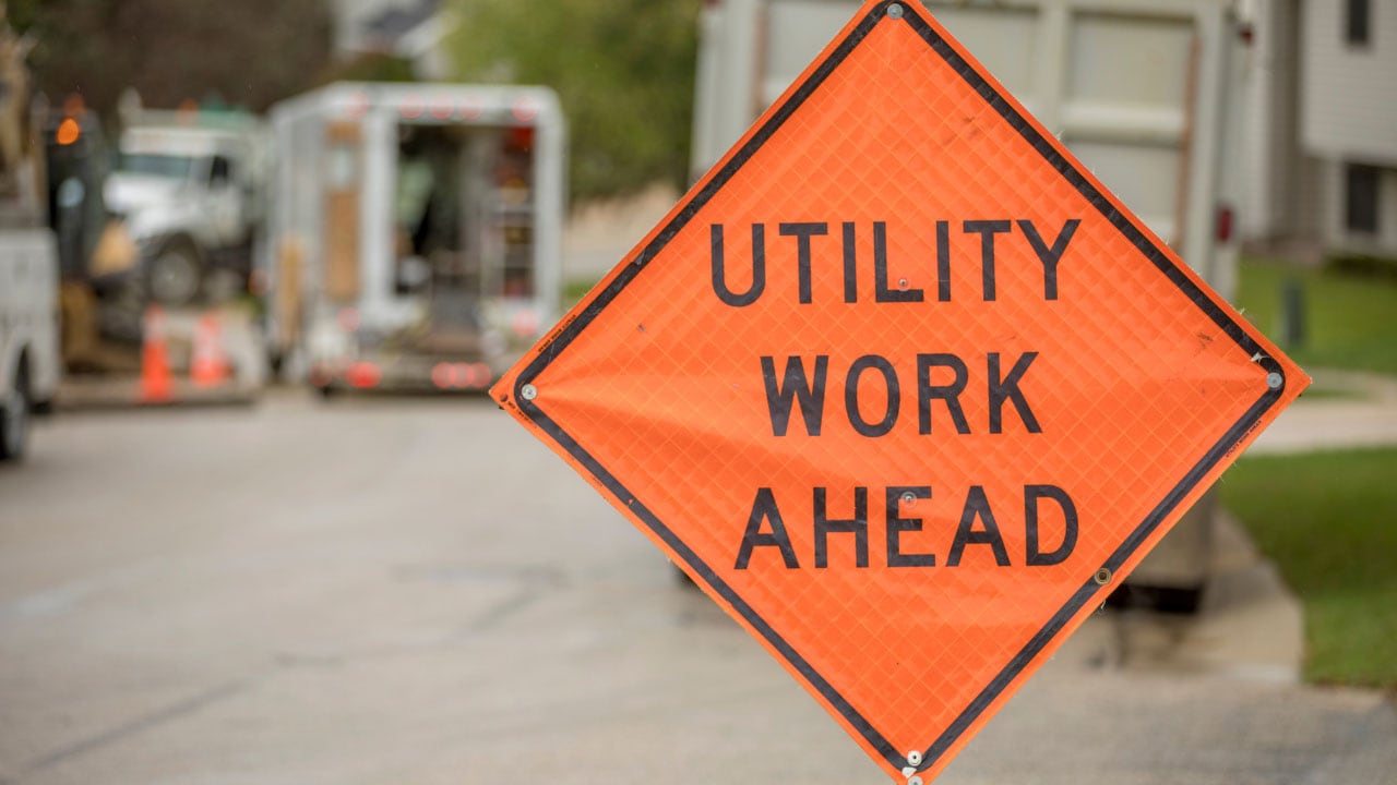
Before starting any excavation project, it’s a legal requirement to notify the relevant authorities and utility operators. This notification must be made a few business days in advance to allow time for utilities to be marked.

Always follow safety protocols to avoid damage to utilities. This includes respecting the markers and avoiding any digging near underground water, gas, or electrical lines. Safety measures are crucial to preventing service disruptions and ensuring the safety of everyone involved.

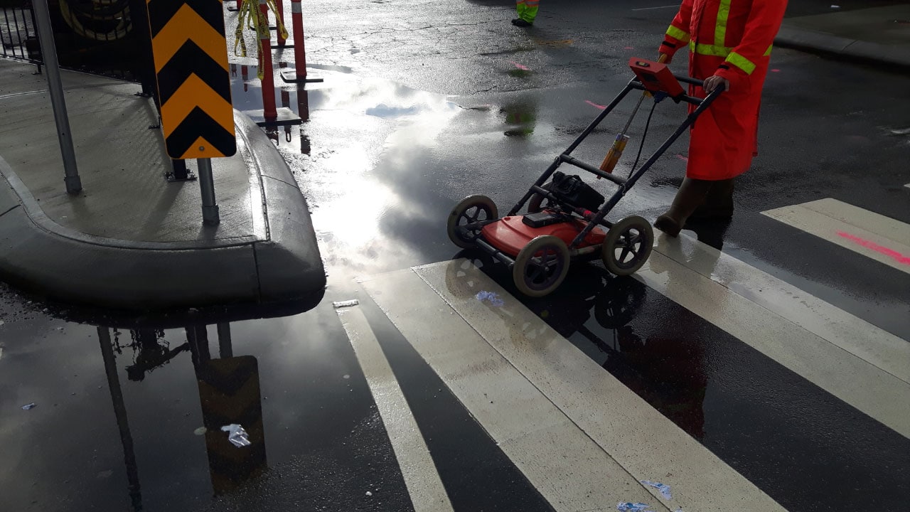
Importance of Professional Utility Locating Services

Preventing utility strikes involves understanding the layout of underground utilities on your property. Professional utility locating services use advanced tools like ground penetrating radar and magnetic locators to identify the precise location of utility lines. This helps avoid accidental damage during digging or construction activities.

Ground penetrating radar (GPR) and metal detectors are commonly used to locate underground lines. GPR is particularly useful for identifying both metallic and non-metallic utilities, while metal detectors are effective for finding metal objects such as pipes and cables.

Hiring utility locating services like Util-Locate ensures that all underground utility lines are accurately located and marked. This prevents accidental strikes and ensures that digging projects can proceed safely. Util-Locate uses advanced technology such as ground penetrating radar to provide precise results.

Find Expert Utility Locating Services in California

Finding an exposed power line is a serious issue that requires immediate action. By contacting your utility company, avoiding contact with the line, and using professional utility locating services in California, you can ensure safety and prevent future problems. Understanding the layout of underground utilities and following safety protocols is essential for any property owner.

Ensure the safety of your property by engaging Util-Locate for professional utility locating services. Our experts use advanced tools like ground penetrating radar to precisely locate underground utility lines, preventing accidental damage and ensuring safe digging. Contact us today to safeguard your home and projects.

How To Find Underground Pipes and Water Lines in Your Backyard

Ground penetrating radar (GPR)

Key Takeaways

  • Ground penetrating radar (GPR) is highly effective for locating all types of underground pipes.
  • Metal detectors are useful for finding metallic pipes and lines with tracer wires.
  • Traditional divining rods can still be used to detect water pipes.
  • Professional utility locating services provide precise identification of all utility lines.
  • Contacting your utility company before digging helps prevent accidental damage to service lines.

Finding underground pipes and water lines in your backyard can seem daunting, but with the right techniques and tools, it becomes manageable. Whether you need to locate water pipes, electrical lines, or gas lines, knowing the location of these utility lines is crucial to avoid damaging them during digging or landscaping projects.

To find underground pipes and water lines in your backyard, you can use a variety of utility locating methods and tools such as ground penetrating radar, metal detectors, and even divining rods.

Common Tools for Locating Underground Pipes

  1. Ground Penetrating Radar – Effective for all types of underground utility lines.
  2. Metal Detectors – Ideal for metallic pipes and lines with tracer wires.
  3. Divining Rods – Traditional method for detecting water pipes.
  4. Metal Rods – Manual checking method.
  5. Acoustic Devices – Useful for sewer lines and other buried pipes.

Methods for Locating Underground Pipes and Water Lines

Ground Penetrating Radar (GPR)

Ground penetrating radar (GPR) is one of the most effective methods for locating underground utility lines. GPR uses electromagnetic waves to create images of the subsurface, allowing you to detect water pipes, sewer lines, and other types of utility lines without any digging.

This method is particularly useful for identifying plastic pipes like PVC pipes that may not be detectable with traditional metal detectors. GPR equipment can scan large areas quickly and provide detailed information on the depth and position of various lines.

Metal Detectors and Tracer Wires

For locating metallic pipes such as copper pipe, metal detectors are highly effective. Many utility lines are installed with tracer wires that can be detected using a metal detector, helping to pinpoint the location of underground water pipes and other service lines.

These tracer wires are often used in conjunction with non-metallic pipes to make them easier to locate. By following the signal from the tracer wire, you can trace the path of the buried lines accurately.

Electromagnetic and Acoustic Methods

The electromagnetic method is another way to locate underground utility lines. This method is especially useful for detecting electric lines and telephone lines. It involves using a transmitter to send an electromagnetic signal through the utility line, which can then be detected by a receiver above ground.

An acoustic method can also be used, where sound waves help identify the presence of sewer lines and irrigation lines. This involves inserting a sound source into the line and using microphones to detect changes in sound patterns that indicate the presence of a line or pipe.

Safety and Legal Considerations

Before starting any digging project, it’s essential to contact your local utility company to mark the location of underground utility lines. This helps prevent accidental damage to service lines, which can lead to serious hazards or service interruptions.

Most areas have a “Call Before You Dig” service that will notify utility companies to come and mark their lines for free. This step is not only a safety measure but also a legal requirement in many regions to prevent unintentional damage to critical infrastructure.

Detailed Guide to Using Locating Tools

Let’s take a closer look at the most common utility locating tools and devices.

Using Ground Penetrating Radar (GPR)

To use GPR, you need to operate the radar unit over the ground surface. The GPR unit sends electromagnetic waves into the ground and records the reflected signals. By analyzing these signals, you can create a detailed map of the subsurface, showing the location of different utility lines.

This method requires some training to interpret the radar images correctly, but it provides a non-invasive way to explore beneath the surface.

Operating Metal Detectors and Tracer Wires

When using a metal detector, walk slowly over the area where you suspect pipes might be located. The detector will emit a sound or signal when it passes over a metallic pipe or tracer wire.

By marking these spots and following the signal, you can trace the path of the underground lines. For tracer wires, connect a transmitter to the wire and use the detector to follow the signal along its length.

Applying Electromagnetic and Acoustic Methods

For the electromagnetic method, attach a transmitter to the utility line and turn it on. The receiver, carried along the ground surface, will pick up the electromagnetic signal, allowing you to trace the line’s path.

The acoustic method involves inserting a small speaker into the pipe and listening for sound variations with ground microphones. This method helps identify the location and condition of sewer lines and other buried utilities.

Practical Tips for Homeowners

By following these guidelines, you can ensure a safe and efficient way to locate underground utility lines and proceed with your backyard projects confidently.

  1. Plan Ahead: Before starting any project, plan the layout and determine where utilities are likely to be located.
  2. Use Multiple Methods: Combine different locating methods for the most accurate results.
  3. Mark and Record: Once identified, mark the locations of all utility lines and keep a record for future reference.
  4. Stay Safe: Always wear protective gear and follow safety guidelines when using locating tools and digging.
  5. Consult Professionals: When in doubt, contact a professional utility locating company to ensure accuracy and safety.

Utility Locating Company and Professional Services

For precise and safe identification of all types of underground lines, hiring utility locating services is recommended. These professionals use advanced tools like ground penetrating radar and electromagnetic methods to locate electric lines, gas lines, and sewer lines efficiently.

Professional locators have the expertise and equipment to detect both metallic and non-metallic pipes, ensuring comprehensive results. They can provide detailed maps and reports that outline the exact locations and depths of all detected lines.

Book Professional Util-Locate Utility Locating Services!

Ready to find all your underground utility lines safely and accurately? Contact Util-Locate today for professional utility locating services in California using the latest technology like ground penetrating radar and more. Protect your home and avoid costly mistakes with our expert services.


Advanced Utility Mapping: Locating Buried Utilities With Real-Time 3D Visualization

real-time 3D visualization

Key Takeaways

  • Advanced utility mapping provides precise detection of underground utilities using cutting-edge technologies.
  • Real-time 3D visualization enhances safety and prevents accidental damage during excavation.
  • Comprehensive 3D models enable efficient project planning and minimize risks.
  • GPR and GIS technologies are essential for creating accurate maps of underground infrastructure.
  • Utility companies, service providers, and city planners benefit from detailed and reliable underground utility mapping.

Advanced utility mapping with real-time 3D visualization offers unparalleled precision and safety in identifying underground utilities. By utilizing cutting-edge technologies, including ground penetrating radar and Geographic Information Systems (GIS), this method ensures accurate detection and mapping of underground assets, preventing accidental damage and enhancing the efficiency of construction projects.

Let’s explore how this innovative approach transforms utility mapping and utility locating services and contributes to safer and more efficient construction projects.

Accurate Detection and Mapping

Advanced utility mapping with real-time 3D visualization provides significant benefits for utility companies, city planners, and construction service providers. This technology offers a comprehensive view of the underground environment, helping to locate water pipes, electrical cables, and other critical infrastructure with remarkable accuracy.

Precision with Cutting-Edge Technologies

Advanced utility mapping employs ground penetrating radar (GPR) and Geographic Information Systems (GIS) to detect and visualize underground utility assets. GPR sends energy waves into the ground, which reflect off different materials such as pipes and cables. These reflections are captured and processed to create detailed 3D images of the underground infrastructure.

Comprehensive 3D Models

The use of real-time 3D visualization enables the creation of 3D models of subsurface utilities. These models provide an accurate and detailed representation of the underground environment, showing the exact location and orientation of utility lines. This information is crucial for avoiding utility strikes during excavation and ensuring that construction projects proceed without delays.

Handling Curved Utilities

One of the challenges in utility mapping is accurately detecting curved utilities such as bent pipes or cables. Advanced 3D visualization technology can capture the precise shape and path of these utilities, ensuring a comprehensive understanding of the underground utility infrastructure.

Enhancing Safety and Efficiency

Precise utility mapping significantly lowers the risk of striking underground utilities, enhancing worker and public safety.

Preventing Accidental Damage

Accidental damage to underground utilities during construction can lead to severe consequences, including service disruptions, financial losses, and safety hazards. By providing an accurate location of underground utility assets, advanced utility mapping helps prevent these incidents, ensuring a safer work environment and reducing project costs.

Efficient Project Planning

With detailed information on underground utilities, city planners and construction service providers can plan projects more efficiently. Knowing the exact locations of underground assets allows for better coordination and reduces the risk of unexpected delays, helping projects stay on schedule and within budget.

Minimizing Excavation Risks

The ability to visualize underground infrastructure in real time minimizes the risks associated with excavation. Workers can dig with confidence, knowing the precise location of utility lines, water pipes, and electrical cables, thereby avoiding potential hazards and ensuring a smoother construction process.

3 Advanced Technologies in Utility Mapping

  1. Ground Penetrating Radar: GPR is a key component of advanced utility mapping. It provides high-resolution images of the underground environment by sending energy waves into the ground and measuring their reflections. This technology is essential for detecting a wide range of underground utilities, from metal pipes to non-metallic conduits.
  2. Geographic Information Systems: GIS technology enhances the accuracy and usability of utility maps. By integrating data from GPR and other sources, GIS creates detailed and interactive maps that can be easily accessed and analyzed. This integration allows for more effective management of underground utility infrastructure and supports informed decision-making.
  3. Real-Time Data Visualization: Real-time 3D visualization provides immediate feedback on the location and condition of underground utilities. This capability is crucial for on-site decision-making and allows for quick adjustments to project plans if unexpected underground assets are detected.

Benefits of Comprehensive Utility Mapping for Various Stakeholders

By leveraging advanced utility mapping with real-time 3D visualization, stakeholders can achieve greater precision, safety, and efficiency in their projects. This innovative approach ensures that all parties have access to accurate and comprehensive information about underground utilities, leading to better decision-making and successful project outcomes.

  • Utility Companies: Advanced utility mapping helps utility companies maintain accurate records of their underground infrastructure. This information is vital for routine maintenance, emergency repairs, and future expansion projects.
  • Service Providers: Construction and excavation service providers benefit from the enhanced safety and efficiency offered by advanced utility mapping. By knowing the accurate location of underground utility assets, they can avoid costly damages and ensure that projects are completed on time.
  • City Planners: For city planners, advanced utility mapping provides a comprehensive understanding of the underground environment. This knowledge is essential for urban development projects, infrastructure upgrades, and planning new construction.

Frequently Asked Questions

1. What is advanced utility mapping, and how does it work?

Advanced utility mapping involves the use of cutting-edge technologies like ground penetrating radar (GPR) and Geographic Information Systems (GIS) to create detailed and accurate maps of underground utilities.

2. What types of underground utilities can be detected with advanced utility mapping?

Advanced utility mapping can detect a wide range of underground utilities, including water pipes, electrical cables, gas lines, sewer pipes, and telecommunications conduits.

3. How does advanced utility mapping enhance safety on construction sites?

By providing an accurate location of underground utility lines, advanced utility mapping helps prevent accidental damage during excavation. This minimizes the risk of service disruptions.

4. What are the benefits of using real-time 3D visualization in utility mapping?

Real-time 3D visualization offers immediate feedback on the location and condition of underground utilities, allowing for on-site decision-making and quick adjustments to project plans. This technology enables the creation of comprehensive 3D models of subsurface utilities.

5. Who can benefit from advanced utility mapping services?

Utility companies, city planners, construction service providers, and excavation professionals can all benefit from advanced utility mapping services. This technology helps utility companies maintain accurate records of their underground infrastructure.

Streamline Your Project With Expert Utility Locating Services Today!

Experience the benefits of advanced utility mapping with Util-Locate’s utility locating services in California. Our expert team uses the latest cutting-edge technologies to provide precise and reliable underground utility mapping. Ensure your construction projects are safe, efficient, and on schedule. Book a consultation now and let us help you locate underground utilities with unparalleled accuracy.

Benefits of 3D Scanning For Utility Mapping

underground utility locations

Key Takeaways

  • 3D scanning ensures accurate detection of underground utilities.
  • Enhances safety by providing exact locations of underground infrastructure.
  • Saves time and money by ensuring projects stay on schedule.
  • Collects comprehensive data on a wide range of underground utility lines.
  • Versatile technology is suitable for various types of subsurface utility investigations.

3D scanning for utility mapping offers numerous benefits, such as accurately identifying the precise location of underground utilities and enhancing the efficiency of construction projects. This advanced technology provides detailed and accurate views of underground utility locations, helping project managers and utility locators make informed decisions that keep projects on track and within budget.

The use of 3D scanning in utility mapping provides significant advantages by delivering a detailed and accurate view of underground utility locations. This technology aids in identifying subsurface utilities, mitigating safety risks, and ensuring that a construction project is completed on time and within budget.

Advantages of Using 3D Scanning to Locate Underground Utilities

3D scanning technology offers significant advantages for utility mapping, including enhanced accuracy, efficiency, cost savings, safety, and comprehensive documentation. Its versatility and ability to improve planning, design, and collaboration make it an indispensable tool in modern utility management.

Accurate Detection and Location

One of the primary benefits of 3D scanning is its ability to accurately detect and locate underground utilities. Traditional methods often rely on outdated maps and guesswork, which can lead to errors and accidents. In contrast, 3D scanning uses advanced ground penetrating radar (GPR) and remote sensing technologies to create precise maps of the subsurface utility environment.

Ground-penetrating radar emits energy waves that penetrate the ground and reflect off different materials, such as pipes and cables. These reflections are captured and processed to generate detailed images, showing the exact locations of underground pipes, cables, and other underground infrastructure. This accuracy is crucial for avoiding damage during excavation and ensuring that underground utility infrastructure remains intact.

Enhanced Safety

Safety is a paramount concern in any construction project, and 3D scanning significantly enhances safety by providing clear and accurate information about underground utilities. By knowing the exact locations of underground utility lines, workers can avoid accidental strikes, which can be dangerous and costly.

Accidental strikes on underground utility infrastructure can lead to severe consequences, including injuries, service disruptions, and financial losses. By using 3D scanning, project managers can minimize these risks and ensure a safer working environment for their teams. This proactive approach not only protects workers but also prevents costly delays and repairs.

Efficiency and Time-Saving

Time is money in the construction industry, and 3D scanning helps save both by providing real-time data that enables project managers to make informed decisions quickly. The detailed and accurate information obtained from 3D scans eliminates the guesswork and reduces the likelihood of encountering unexpected underground utility issues during excavation.

With 3D scanning, projects can proceed more smoothly and efficiently. The ability to identify underground utility locations accurately means that excavation and construction can be planned more effectively, reducing the time spent on site and minimizing disruptions. This efficiency is crucial for keeping projects on schedule and ensuring that they are completed on time.

Comprehensive Data Collection

3D scanning gathers extensive data on a wide range of underground utility locations. It utilizes remote sensing technologies to capture images and detect underground utility lines, providing a detailed map of the subsurface utility environment. This comprehensive data collection is invaluable for subsurface utility investigations and helps in creating accurate records of underground utilities.

The data collected by 3D scanners includes information on the type, size, and depth of underground utilities. This information is essential for planning and executing construction projects safely and efficiently. It also allows for better coordination between different stakeholders, such as utility companies, contractors, and project managers, ensuring that everyone has access to the same accurate information.

Versatility

3D scanning is a versatile technology that can be applied in various scenarios, including subsurface utility investigations and private utilities. It can accurately map a wide range of types of utilities, from water and gas lines to electrical conduits, aiding in comprehensive underground utility mapping. This versatility makes it an invaluable tool for different types of construction projects, whether they involve residential, commercial, or industrial sites.

The ability to map different types of underground utilities accurately is particularly important for projects that require excavation or drilling. By knowing the precise location of these utilities, project managers can avoid damaging them and ensure that the construction work proceeds smoothly. This versatility also makes 3D scanning an essential tool for utility companies and municipalities, which need to maintain accurate records of their underground utility networks.

By embracing 3D scanning for utility locating services, you can significantly improve the precision and safety of your construction projects, ensuring they are completed on time and within budget. This technology not only enhances efficiency but also provides peace of mind, knowing that your project is built on a solid foundation of accurate and comprehensive utility mapping.

Ground Penetrating Radar: How It Works

3D scanning employs ground-penetrating radar and other remote sensing technologies to emit energy waves that penetrate the ground. The reflections from these waves are then captured and processed to create detailed images of the underground utility infrastructure. This method is non-invasive and highly effective in locating underground utility lines without digging.

The process begins with the deployment of a 3D scanner over the area of interest. The scanner emits energy waves that travel through the ground and reflect off different materials, such as metal, plastic, and concrete. These reflections are captured by the scanner and processed to create a detailed 3D map of the underground utility environment.

The resulting images provide a clear and accurate representation of the underground utility network, showing the exact locations of underground pipes, cables, and other infrastructure. This information is then used by utility locators and project managers to plan and execute construction work safely and efficiently.

Find Expert Utility Locating Services Today!

Experience the benefits of cutting-edge 3D scanning technology with Util-Locate’s utility locating services. Our expert utility locators are equipped with the latest tools to provide precise underground utility detection and mapping.

Don’t wait until it’s too late – ensure your construction project runs smoothly and safely. Contact Util-Locate now and let us help you locate underground utilities with unmatched accuracy and efficiency.