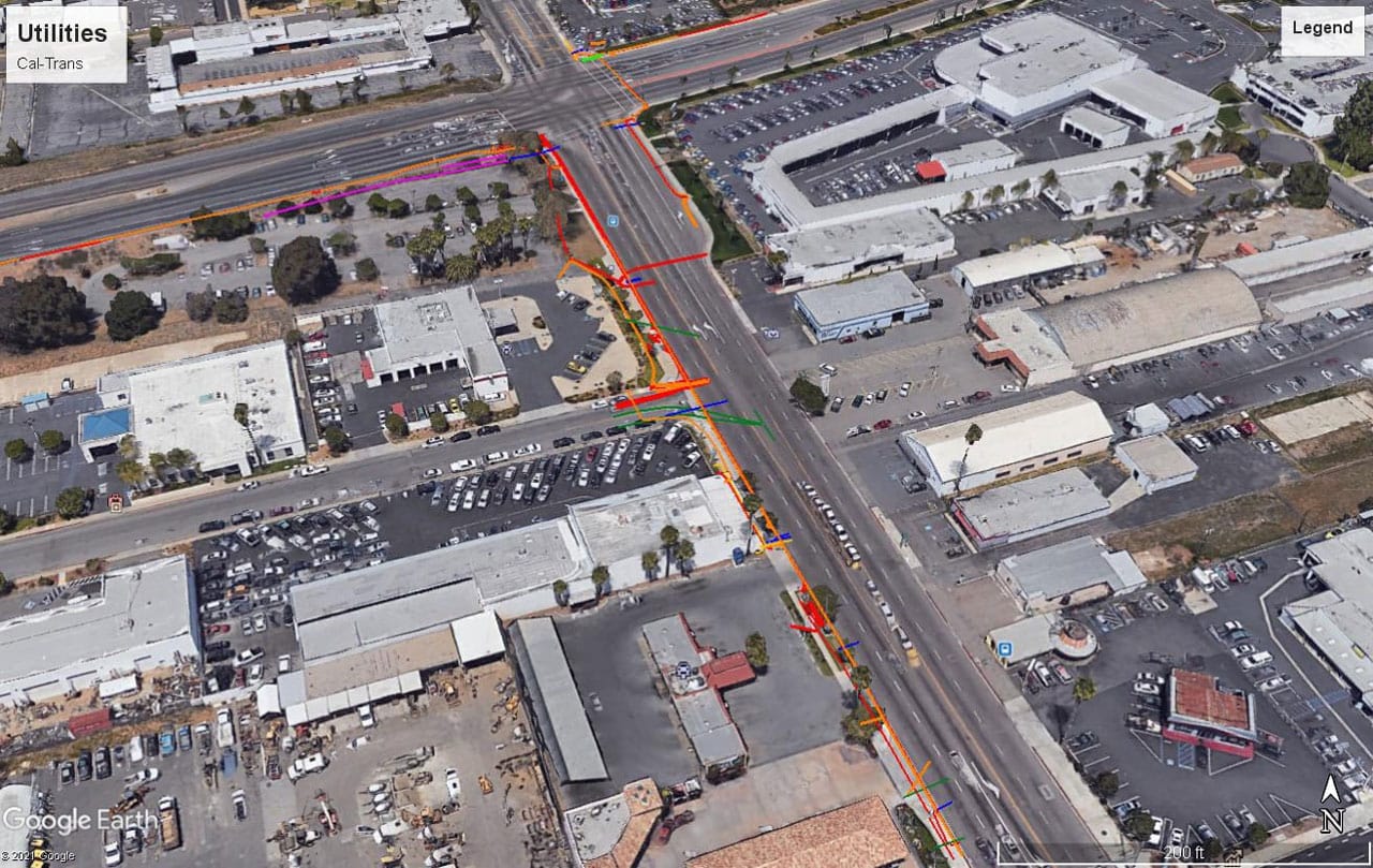
Utility mapping plays a crucial role in the construction and maintenance of urban infrastructures. However, the process involves inherent risks that can significantly impact project outcomes and safety. A thorough risk assessment process is essential to identify these potential risks and develop effective mitigation strategies.
The Essentials of Risk Assessment in Utility Mapping
The application of advanced technology in utility locating and mapping is revolutionizing the construction industry’s approach to risk mitigation. Ground Penetrating Radar (GPR) locating services and private utility locating are at the forefront of this change, offering unparalleled accuracy and reliability.
By integrating these technologies into utility mapping processes, the risk of accidentally damaging underground utilities—a prevalent issue that leads to significant project delays and financial losses—is substantially reduced.
Identifying Potential Risks
The first step involves identifying potential hazards associated with utility locating and mapping, such as damaging underground utilities, encountering natural hazards, or operational risks. Utilizing tools like GPR services, utility locating services, and underground utility mapping helps pinpoint these risks early in the project.
Risk Analysis and Assessment Tools
Employing a systematic approach, such as risk assessment matrices and risk assessment models, allows project managers and risk assessors to evaluate the level of risk associated with identified hazards. This includes both qualitative risk analysis and, where applicable, quantitative measures to assign numerical risk scores to different scenarios.
Developing Risk Management Strategies
Based on the identified risks and their potential impacts, developing effective risk management strategies is crucial. This could involve employing advanced GPR scanning services, implementing internal controls, or revising operational procedures to mitigate identified risks.
Enhancements Brought by GPR and Private Utility Locating
- Improved Accuracy: Ground Penetrating Radar (GPR) services, through their advanced scanning capabilities, can detect a variety of subsurface structures, including non-metallic and metallic utilities, providing a comprehensive view of the underground infrastructure. This level of detail ensures that all potential hazards are identified before excavation begins, significantly reducing the likelihood of accidental damage.
- Time Efficiency: Private utility locating speeds up the pre-construction phase by quickly identifying the exact location of utilities. This expedites project timelines by eliminating lengthy trial-and-error excavation processes and preventing unforeseen delays caused by utility repairs.
- Safety Enhancement: The precise mapping afforded by these technologies mitigates safety hazards for construction workers and the general public. By accurately locating utilities, the risk of encountering dangerous lines such as gas or electric is minimized, fostering a safer work environment.
Utilizing the Risk Assessment Matrix and Establishing Risk Criteria
The risk assessment matrix is an essential tool in construction project planning and utility mapping. By categorizing risks based on their severity (the potential consequences) and likelihood (the probability of occurrence), project managers and risk assessors can make informed decisions about where to allocate resources and which mitigation strategies to implement.
Key Components of an Effective Risk Matrix
- Severity and Likelihood: The matrix allows for a visual representation of risks, making it easier to identify which ones require immediate attention and which are less critical.
- Risk Criteria Definition: Organizations must establish clear criteria for what levels of risk are acceptable. This involves considering the organization’s risk appetite, the potential impact on project outcomes, and legal or regulatory requirements.
- Prioritization of Risks: By sorting risks into categories, from high to low, teams can prioritize their risk management efforts, focusing on mitigating the highest-level risks first to ensure the most efficient use of resources.
Adopting a Systematic Approach to Risk Management
Effective risk management in utility locating and construction requires a holistic approach that spans the entire project lifecycle. This systematic approach not only identifies and assesses risks but also develops strategies to manage or eliminate them.
Steps in a Systematic Risk Management Process
- Hazard Identification: This initial phase involves using technologies like GPR scanning to identify potential underground hazards, setting the stage for a more informed risk assessment.
- Risk Assessment and Planning: Utilizing the risk assessment matrix, project teams evaluate identified hazards to understand their potential impact on the project and develop a risk assessment plan.
- Implementation of Risk Controls: Based on the risk assessment, appropriate controls are put in place to mitigate identified risks. This could involve adjusting construction plans, implementing safety measures, or employing alternative techniques to avoid sensitive areas.
- Monitoring and Review: Risk management is an ongoing process. As such, the implemented strategies and controls must be regularly reviewed and adjusted based on new information or changes in the project scope.
By integrating advanced utility mapping technologies and adopting a systematic risk management approach, construction projects can significantly reduce the potential for accidental utility damage, ensure the safety of workers, and maintain project timelines. This holistic approach ensures that potential issues are systematically identified, assessed, and managed, contributing to the overall success and sustainability of urban development projects.
Collaboration and Expertise
Collaboration between project managers, utility service providers, and subject-matter experts is essential for successful risk management in utility mapping. Brainstorming sessions and risk assessment meetings facilitate the sharing of knowledge and experiences, enhancing the overall risk assessment process and ensuring that all potential risks are adequately addressed.
Effective risk assessment in utility mapping is vital for safeguarding organizational objectives and ensuring the health and safety of all stakeholders involved. By adopting effective risk assessment techniques and leveraging the latest advancements in utility locating technology, projects can significantly reduce the potential consequences of unseen hazards.
Partner with Util-Locate for Comprehensive Risk Assessment and Utility Mapping Services
At Util-Locate, we specialize in providing state-of-the-art utility locating and mapping services, equipped with the latest technology and expert knowledge to identify and mitigate risks in your construction projects. Our experienced team is committed to ensuring the safety and success of your projects in Southern California.
Reach out to Util-Locate to integrate advanced risk assessment and utility mapping solutions into your project planning. Move forward with confidence, knowing your project is backed by expert analysis and support!

